The geology of Maliau Basin
It is described as a crater constantly, and it is not one. There was no impact and no volcano. Maliau is a sedimentary formation whose resemblance to a caldera is a coincidence of how erosion worked on tilted rock.
No. Despite the circular shape and the nickname, Maliau Basin is a sedimentary basin, not a volcanic caldera or an impact crater. It is formed from tilted beds of sandstone and mudstone laid down on a sea floor around 16 to 17 million years ago — marine gastropod fossils survive in the rock — then uplifted and eroded. Alternating hard and soft layers explain the stepped landscape and the unusual number of waterfalls. The escarpment rim rises above 1,675 m and the northern high point has never been accurately surveyed.
Roughly 25 km across; the whole basin drains through one gorgeWhy Maliau Basin is not a crater
Look at it from above and the conclusion is understandable. A roughly circular bowl about 25 kilometres across, walled on almost every side by cliffs and near-vertical slopes, with a flat-ish interior and one narrow outlet. It reads as a caldera.
But the rock says otherwise. The basin is built from gently inclined beds of sandstone and mudstone — sedimentary layers, laid down in water, later uplifted and tilted. There is no volcanic rock and no impact melt.
What produced the shape is differential erosion. Where tilted beds of harder and softer rock are worn back at different rates, the resistant layers stand as escarpments and the soft ones hollow out behind them. Do that around a structural dome or basin and you get a ring of cliffs enclosing lower ground. It is a landform type, not an event.
 img/geo-escarpment-beds.jpgTilted sandstone beds in the escarpment wall21/9
Sea snails in the middle of Borneo
If the sedimentary explanation needs proof, the area supplies it. Fossilised marine gastropods have been recorded in the surrounding rock, dated to roughly 16 to 17 million years old.
Sea snails, hundreds of kilometres inland, at altitude, in the interior of Borneo. Those beds were laid down on a sea floor in the Miocene and subsequently lifted to their present elevation. You cannot get that outcome from a volcano or an impact.
The fossils occur in the same part of the conservation area as Lake Linumunsut, in the extension area beyond the escarpment rim.
The giant staircase, and why Maliau has so many waterfalls
The Murut name for the area translates roughly as the land of the giant staircase, and that is a geological observation as much as a poetic one.
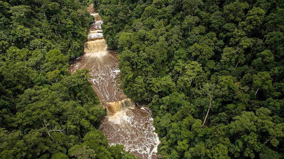
Alternating hard and soft sedimentary beds, tilted and then cut by rivers, produce a stepped profile. Water runs across a resistant layer, drops where it meets a softer one, and repeats. Stack enough of those steps and you get a landscape of cascades.
This is why Maliau has more waterfalls than anywhere else in Malaysia, and why Maliau Falls drops in seven distinct tiers rather than one. The seven tiers are seven bedding planes. The full waterfall list is here.
 img/geo-staircase-falls.jpgStepped cascade over bedding planes3/2
 img/geo-sandstone.jpgSandstone outcrop in the basin interior3/2
A closed catchment with a single outlet
Because the rim is nearly continuous, the basin functions as one enclosed catchment. Every stream inside it feeds the Maliau River, which escapes through a gorge in the south-east corner into the Kuamut and then the Kinabatangan, Sabah's longest river.
That single-outlet structure has consequences well beyond hydrology.
- Nobody settled here. A bowl walled by cliffs with one narrow breach is extremely hard to enter or farm. No permanent settlement was ever established inside, and the first proper scientific expedition into the interior came only in 1988.
- The water chemistry is distinctive. Drainage through peaty leaf litter and heath forest produces oligotrophic water — low in nutrients, highly acidic, stained tea-brown by tannins. Very few fish, and high amphibian diversity as a result.
- The soils are poor. Which is why the montane heath forest and its nine pitcher plant species exist at all.
The rim has never been properly surveyed
The highest point sits on the northern rim at over 1,675 metres — and by the admission of the conservation area's own management, it has still not been accurately surveyed.
That single detail says more about Maliau than any superlative. A landform of this size, in a state as well mapped as Sabah, with an unmeasured high point. Roughly a third of the basin is open to visitors and less than half has been properly explored even by researchers.
Studies Centre stays from RM3,500, treks from RM4,990 — every package compared on one page.
Maliau Basin geology questions
Is Maliau Basin a crater?
No. Despite the circular shape it is a sedimentary formation built from gently inclined beds of sandstone and mudstone. There is no volcanic rock and no impact evidence. The bowl shape results from differential erosion of tilted hard and soft rock layers.
How was Maliau Basin formed?
Sedimentary beds of sandstone and mudstone were laid down in a marine environment, later uplifted and tilted. Erosion then wore back the softer layers faster than the resistant ones, leaving a ring of escarpment enclosing lower ground.
Are there marine fossils at Maliau Basin?
Yes. Fossilised marine gastropods roughly 16 to 17 million years old have been recorded in the sedimentary rock of the area, direct evidence that the beds forming the basin were deposited on a sea floor before uplift.
Why does Maliau Basin have so many waterfalls?
Because alternating hard and soft sedimentary beds, tilted and then cut by rivers, produce a stepped profile. Water drops wherever it crosses from a resistant layer onto a softer one. Maliau Falls' seven tiers are seven bedding planes.
How big is Maliau Basin?
The conservation area covers 588.4 square kilometres, of which the basin itself accounts for about 390. The bowl is roughly 25 kilometres across, and the highest point on the northern rim rises above 1,675 metres.
Has Maliau Basin been fully surveyed?
No. The highest point on the northern rim has still not been accurately surveyed according to the conservation area's own management, roughly a third of the basin is open to visitors, and less than half has been properly explored by researchers.
See the tilted beds for yourself
The escarpment and the stepped falls are clearest from the trekking loop.
Read the trek loop Enquire